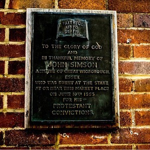
History of Market Square (HT)
The market has always been at the heart of the town of Rochford, right from when it was granted its first charter in the mid-13thcentury. Indeed there is no evidence of settlement in the historic centre of Rochford, the area bounded by North Street, East Street, South Street and West Street, before the market was founded, so the town grew up around the market. The settlement that is mentioned in the Domesday Book was therefore probably located closer to Rochford Hall.
The charter of 1247 permitted the market to be held every Tuesday and for fairs to be held on the Tuesday and Wednesday of Easter week, on the Monday, Tuesday and Wednesday following Whitsunday (six weeks after Easter) and on the Wednesday after Michaelmas (29thSeptember, one of the traditional quarter days on which rents were due). In 1264, an additional charter allowed an extra fair to be held at All Hallows (31stOctober to 2ndNovember) each year.
The market originally covered a much larger area than the present square. It would have included the land now occupied by the buildings around the square, extended eastward across North Street into the area now bounded by Old Ship Lane and East Street and probably had Back Lane as its southern boundary. Back Lane acted as the through route on market and fair days. Excavations under parts of the Horner’s Corner site have found 13thand 14thcentury surfaces consistent with a market.
One item of interest is the line that East Street takes from its junction with Old Ship Lane to Horner’s Corner. Coming in from the east of the town, East Street fits in to the same rectilinear pattern as the other three main roads. However, when it reached its junction with Old Ship Lane, it met the edge of the original market. What is known as a “desire line” was then created as people who wanted to get around the market walked down the side of it to reach the other roads at what is now Horner’s Corner. Over time this became the road. Old Ship Lane probably has similar origins.
Medieval markets were different to the genteel affair we see in the square today. Vendors would sell from carts or set up booths, stalls or tents to protect themselves and their goods from the elements. This was the only place you could buy anything as there were no shops, so all the goods and services that you needed were to be found here. This would include produce, livestock, meat, fish, grain, flour, pies, beer and all the other staples. Also there would be oil, candles, nails, cloth, wool and rope. Unlike the markets, which were largely local affairs, the larger fairs attracted traders from further afield, sometimes bringing exotic goods from other parts of the country and even overseas.
Craftsman such as smiths, coopers (barrel makers), wainwrights (waggon makers), farriers, tanners, carpenters, potters and potion sellers would be present making and selling their wares. There would be entertainment in the form of acrobats, jugglers, cock fighting and even dancing bears.
Most of the produce would be brought in from the surrounding countryside, but some of the sellers of the more exotic goods and the craftsmen, may have travelled around various markets.
The plots occupied by each vendor were not random, but were laid out by the market officials who worked for the lord of the manor who held the market charter. The vendors would pay the market officials a fee to occupy a plot on market day and at fairs and the proceeds would go to the lord.
The property known as King’s Hillin East Street dates from within fifty years of the founding of the market and may well have been its administration building. Today it seems remote from the market square, but back then, it would have been right on the edge of the action. Along with the Old Housein South Street, it may well be one of the oldest surviving buildings in Rochford.
Over time, some of the traders would have erected more permanent structures on their plots, in place of their booths and may have started living in them, rather than traveling from market to market. This is known as infilling. The market officials would have started charging them rent and the traders may have even bought their plot.
In Rochford, the area bounded by North Street, Old Ship Lane and East Street, the area between North Street and the present market square, the area between West Street and Back Lane, the land now occupied by the properties around the market square and possible the properties along West Street, are where this occurred, thus establishing the present building plot layouts in many cases. Excavations at Horner’s Corner found evidence of 15thand 16thcentury buildings above the 14thcentury market surface and the building here now still incorporate remnants from those buildings.
The town grew up around the market and its fortunes waxed and waned along with those of England up until the turn of the 18thcentury when the market collapsed. The locals were unhappy about this as the nearest market was now over twenty miles away, so in 1707 it was revived.
In that year, a market hall was built. It stood in front of the middle third of the row of cottages on the north side of the square and projected westward to a point roughly in line with the eastern end of the King’s Head. It may have had a medieval predecessor on the same site. It was a two storey wooden structure. It had a clock on the south side projecting out from the first floor. It also had a tower with a weather vane on top.
The ground floor had open sides formed by a series of wooden arches. It had pig pens, a barber-dentist and a drunk cage. The first floor was used for weighing wool, a very important commodity in this area, and may have had offices for the market officials as well. In 1857, the market had closed again and by 1861 the market hall had become derelict and was demolished.
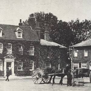
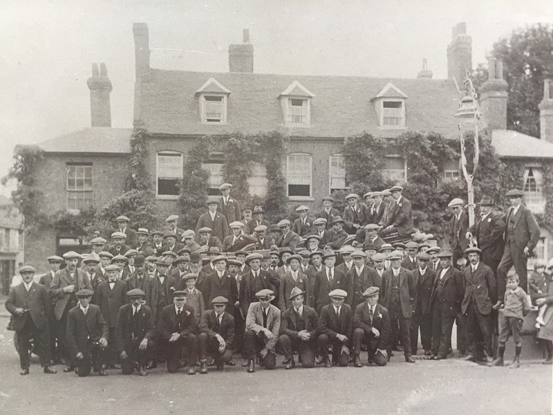
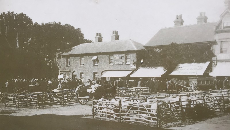
In 1914 a cattle market started in the square and was held every Thursday up to 1959. Pens made of wooden hurdles were erected in the square into which sheep and pigs up for sale were put. A railing was put in front of all the shops to protect them from cattle for sale, which were tied to the railings.
The auction ring was in the north west corner of the square and a bell rang at 1pm to start the auctions. There was also a sheep sale once a year using the whole square. At the end of the market, cattle were driven down West Street to the Freight House to be loaded onto trains for transportation to Smithfield and elsewhere.
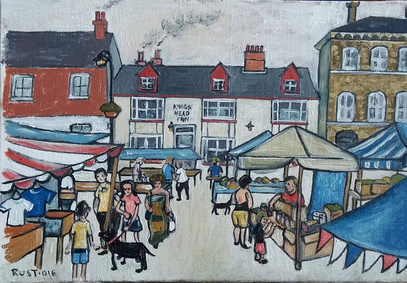
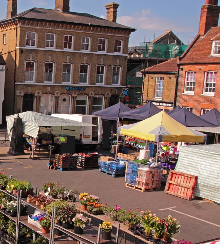
During the 1960s and early 1970s, with no markets being held, the square was rather neglected, but in 1977, the weekly Tuesday market with stalls selling a range of goods was revived and has been running ever since.
In terms of buildings and other objects of interest, around the square there is a variety of styles and periods to see. Starting in the square itself, on the traffic island by the taxi rank, the horse trough and the pump can be seen. The iron pump was originally installed in 1820 and was removed in 1902. It stood on top of the well which although now covered up, still exists under the square.
To find where it was, project an imaginary line from the bollard on the traffic island just to the east of the trough across the square to the point opposite on the parade of shops on the north side. Then project another imaginary line from the entrance to Connaught House on the west side of the square to a point opposite in the row of shops on the east side. The well is located where the two lines cross. There was iron staging down to the water level.
The Horse Trough was installed in 1901 to commemorate the coronation of King Edward VII. It originally had a gas street light, made by Whittingham’s, on it. You can still see where it was mounted. The trough was removed in 1953 to make way for a bus shelter and stood for many years outside Hockley Woods.
In 2002 the square was given a facelift. This is when the traffic island was installed. The pump and horse trough were included as part of the scheme, but it was decided it was not practical to put the trough and pump back to their original position so they were placed on the traffic island where they are now, although in history they only ever stood together for about a year as the trough was installed originally in 1901 and the pump was removed in 1902.
The original pump was long lost, so a replica was used. However the trough was returned from Hockley Woods. It was initially used as a planter, but it was then left empty. It was eventually filled in with cobbles and concrete as it was being used as a rubbish bin and passing gentlemen were finding it a bit too “convenient” late at night!
Now for a look at the buildings around the edge of the square. Starting in the south west corner, across the road from the pump, is the Women’s Institute Hall, which is described in a separate entry.Next door to this on the south side of the square is the magnificent building that is today known as Nos. 15-17 West Street. This Grade II Listed Building was built in the early 19thcentury to house the Rochford Hundred and Billericay Bank, the first of its kind in the town. It housed banks ever since until Barclays Bank vacated the premises in 2017.
It is built of Yellow Stock bricks using Flemish bond, which is where each row of bricks has alternate headers (the end of the brick) and stretchers (the side of the brick) along it. This style was popular in the late 18th and early 19th centuries. It has stone dressings, is three storeys high with projected eaves and is symmetrical in design.
It has a hipped grey slate roof with three large brick chimney stacks, the capping and bases of which are moulded. The eaves have moulded brick brackets and bands to form the cornice. The first and second storeys have six vertical sash windows on each floor with horns and moulded segmental heads. The second floor windows have moulded jambs. The first floor windows are similar, but also have ornate keystones. Both storeys have a stone band below the windows.
The ground floor has four central windows similar to the first floor with attached shafts with capitals and bases forming the jambs and stone panels with foliate carved motifs between the arches. There is a door at each end with the same detailing as the windows and each door has a fanlight above it.
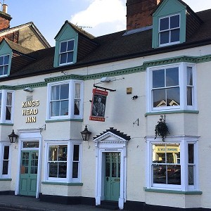
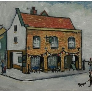
Crossing King’s Head Alley, the next building is the former King’s Head Hotel, which is described in a separate entry.Next door to the King’s Head is No. 9 West Street, another Grade II Listed Building. It dates from the 18thcentury and is of red brick with Flemish bond. It has a red brick chimneystack topping the roof of its three stories. The second floor has two vertically sliding sashes with horns. There is a moulded and dentil band extending the full width of the front above the first floor.
The first floor has two large bow windows to first and ground floors. The ground floor also has small paned shop bay windows with moulded cornice and soffit boards forming a continuous fascia above them and the central doorway which has fluted pilasters and frieze with patera in the panels. These are a legacy from when it was a tea shop. There is a round headed doorway on the left hand side leading to the upstairs.
No 7 West Street was once the site of an ancient wooden building, but this was demolished and replaced with the 20thcentury building now occupy the plot, which was built to blend in with its neighbours.
Crossing over West Street, the east side had some 16thcentury wooden cottages at its northern end which were demolished in 1961 and some 19thcentury cottages at its southern which were demolished in 1973. It was part of a bid to modernise Rochford which was never completely carried out. The current row of 1970s shops follow the original building line. These are typical of the period being of red stretcher bonded brick with a flat roof. Stretcher bond is where the bricks are laid end to end and overlap the row below. The walls often consist of two parallel walls of brick with a cavity in-between.
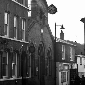
The north side was partially destroyed in 1884 by a fire in the paraffin store of Ashby's ironmongers. It was subsequently rebuilt and now houses the hardware shop, estate agents and newsagent. The block containing the hardware shop looks largely as it was before the fire, a tall Victorian building with yellow Flemish bond brick work and dormer windows in the roof. The building that is now the newsagent has a heavily modified front façade and a small cottage next to it at the entrance to the alley through to North Street has been lost.
The block of two shops to the immediate west of the hardware shop are both Victorian with yellow Flemish bond brickwork. The last two buildings in the row are from the 1970s, but were designed to try and blend in with the other older buildings in the row. There was originally a saddlery in a building dating from 1777 on this site. It was demolished one Sunday in the 1970s without the permission of the Council who, because it was a Sunday, were powerless to prevent it.
Moving to the west side of the square, the first building dates from the 20thCentury and is built in a Georgian style. It replaces an ancient wooden cottage called Fernbank which was demolished. Next door isNo 34 West Street also known as Connaught House, which is described in a separate entry. Outside Connaught House is a K6 Telephone Box dating from 1935. It is a Grade II Listed Building in its own right. The tour around the square ends with another 19thcentury yellow stock Flemish bond cottage, now used as a shop.
The destruction of the saddlery, along with the loss of buildings in other parts of the square and town, led to pressure to halt the modernisation and list and protect what was left. This was successful and saved much of Rochford’s heritage for the future.